The Polis Center at IUPUI collaborates to create innovative place-based solutions that lead to healthier and more resilient communities. We do this by creating actionable information, develop creative collaborations, do place-based research, and employ technology effectively to enhance the capacity of communities to respond meaningfully to change.
Geospatial technologies, especially GIS, are our preferred technical tools because of their unique ability to integrate and visualize information by location. We use these tools to develop and analyze data for communities and then involve local experts in helping to understand what the results mean. In doing so, we help communities make more productive decisions.
As part of the 2019 update of Indiana’s Multi-Hazard Mitigation Plan, Polis leveraged Real Property Tax Assessment Data from the Indiana Department of Local Government Finance (DLGF) to determine the financial impact on Indiana property in the event of a disaster. This dataset covers all 92 counties in Indiana and is a treasure trove of information which the Polis Center uses for many different applications. We recently looked at DLFG property data to identify areas more at risk of climate change, including temperature increases and tornado frequency.
Temperature
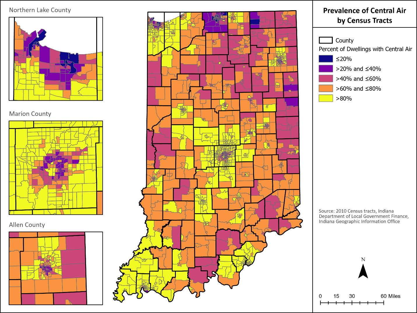
The Indiana Climate Change Impacts Assessment (IN CCIA) from 2018 found that temperatures are projected to rise about 5-6°F by mid-century and that the number of extremely hot days will rise. This increase in extremely hot days may disproportionately affect Hoosiers who do not enjoy air conditioning at home or work. We wondered how the state would be affected and looked at the DLGF property data about dwellings (residential structures) that have central air conditioning. The map below shows the proportion of dwellings with central air by US Census Tract. As you can see, there are vast differences throughout the state. Suburban areas tend to have a larger proportion of dwellings with central air while rural areas along with inner cities tend to have a lower proportion of dwellings with central air. A significant portion of the state will experience discomfort with rising temperatures with little opportunity of relief if this pattern continues.
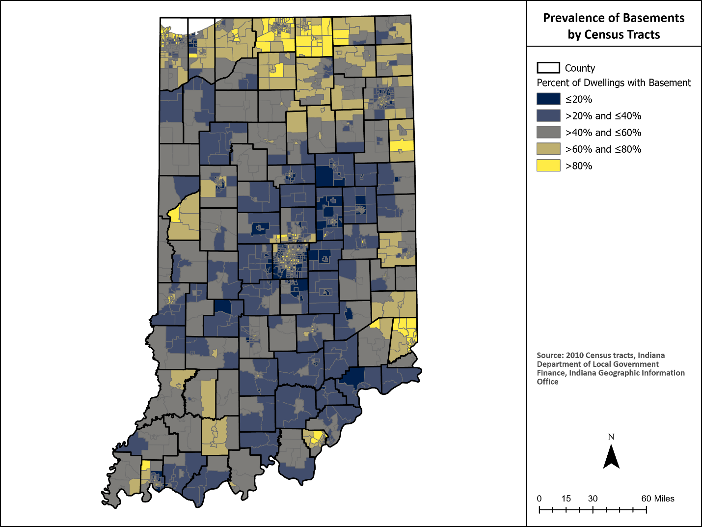
Tornadoes
New research appears to demonstrate that while “national annual frequencies of tornado reports have remained relatively constant, […] significant spatially-varying temporal trends in tornado frequency have occurred since 1979” (Gensini & Brooks, 2018). Indiana is one of the states showing this upward trend in tornadoes. Historically, tornadoes occured most frequently in the sourthwest, over less populated areas. This increased frequency and spatial varying will put more residents and property at risk of tornado occurrences. Basements are often used as a shelter area during a tornado warning. In spite of the number of tornado incidents in Indiana, however, many dwellings do not have a basement. The map below shows residences with a basement. People with no basement are encouraged to move to a small interior room on the lowest level or, if there is time, proceed to a sturdy building or shelter in the community. Traveling to a safe area takes time and communities with a low incidence of basements would benefit from earlier warnings than others to give residents time to find shelter. As shown, many residents in Indiana require notice as far in advance as possible to find a safe place to ride out the storm.